


When GPS signals are interfered with, spoofed, or completely disrupted, are there alternative solutions? A research team from The Ohio State University has provided a surprising answer: using continuous radio beacon signals broadcast by SpaceX Starlink satellites for positioning, achieving an accuracy of 2 meters with hardware costs under $200 (approximately NT$6,500). This technology is not just theoretical. In early 2026, the same team completed real-world testing on ground vehicles, drones, stratospheric balloons, and vessels in Arctic waters, covering all four scenarios: land, air, high-altitude, and maritime.
An academic team uses less than $200 of hardware to receive Starlink satellite signals as a GPS replacement
The Secret Signal That Starlink Satellites Keep Broadcasting
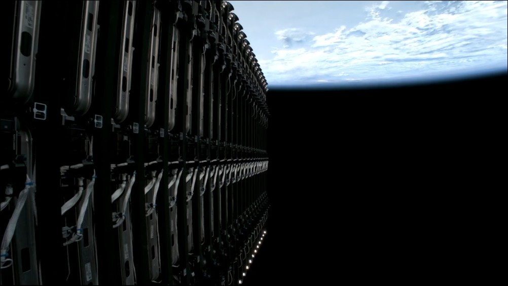
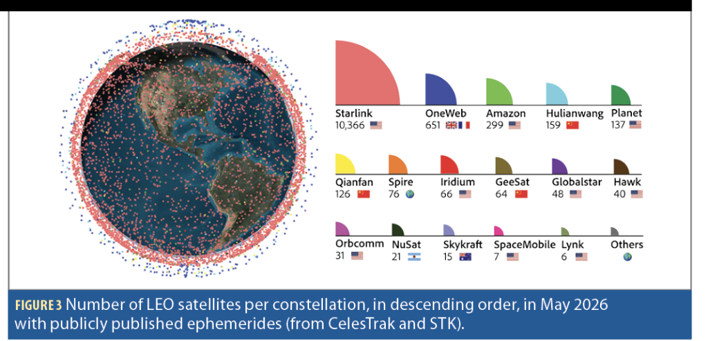
Starlink is a low Earth orbit (LEO) satellite network deployed by SpaceX, with over 10,000 satellites in operation by early 2026, surpassing the combined total of all other LEO satellites in human history. The primary mission of these 10,000+ satellites is to provide global broadband internet service, but each satellite continuously transmits beacon tones in the Ku band (approximately 10.7 to 12.7 GHz). Beacons are similar to a satellite’s “heartbeat” and are necessary for the satellite’s own orbital management and collision avoidance.
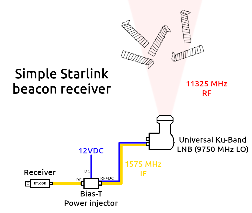
However, beacon signals are publicly broadcast and can be received without logging into the Starlink network. Anyone with the appropriate receiving equipment can “eavesdrop” on satellite beacon signals. As early as 2021, an amateur radio enthusiast named sgcderekblogIt demonstrates how to successfully receive beacon signals from Starlink satellites using a Ku-band low-noise block downconverter (LNB) paired with an RTL-SDR software-defined radio receiver.
From Signal Reception to Localization: A Scientific Breakthrough
Receiving signals is one thing; using signals for positioning is a completely different level of challenge. This is precisely the core contribution of Ohio State University’s ASPIN Lab (Autonomous Systems Perception, Intelligence, and Navigation Laboratory). Led by Professor Zak Kassas, the lab first demonstrated positioning using Starlink signals at the ION GNSS+ conference in 2021.Experimental resultsThe team developed a cognitive software-defined receiver (cognitive SDR) that can learn and track Doppler shifts in satellite signals in real time without prior knowledge of Starlink signal structures.
Professor Kassas stated at the time: “We eavesdropped on the signals, then designed sophisticated algorithms to locate them, and the results proved to be highly accurate. Although Starlink wasn’t designed for navigation, we demonstrated that it can be used for navigation.”
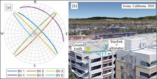
The first experiment in 2021 started from an initial estimated position 180 kilometers away, and by tracking signals from 6 Starlink satellites, ultimately positioned the receiver within 10 meters. Over the next few years, the team continued to refine the algorithm, improving accuracy to an impressive 2 meters.
Decoding the Complete Starlink Beacon: 18 dB More Gain Than Previous Literature
In 2025, the ASPIN Laboratory published a groundbreaking [study/article] in the journal NAVIGATIONPaperThis is the first complete disclosure of Starlink’s OFDM (Orthogonal Frequency Division Multiplexing) beacon structure. The Primary Synchronization Sequence (PSS) and Secondary Synchronization Sequence (SSS), previously known in the literature, account for only 0.66% of Starlink’s complete OFDM beacon.
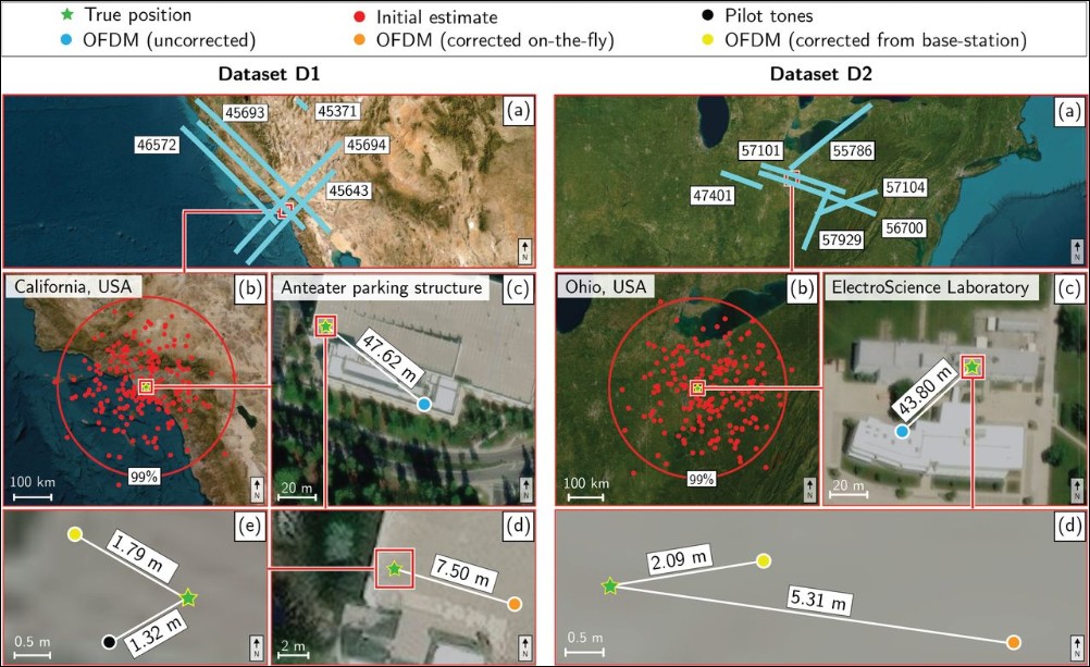
Using full OFDM beacons for signal processing, the processing gain is improved by nearly 18 dB, allowing receivers to simultaneously track more satellites and enabling reliable signal acquisition and tracking even on low-gain antennas (such as cheap LNBs). Experiments show that by simultaneously tracking an average of just 3 Starlink satellites, 3D positioning accuracy with 2-meter error can be achieved within 20 seconds.
Real-world testing verification across four mobile platforms
Early 2026, GPS World magazine featured the latest achievements of the ASPIN Lab in a cover story: completing Starlink LEO navigation tests on four geographically distributed mobile platforms.
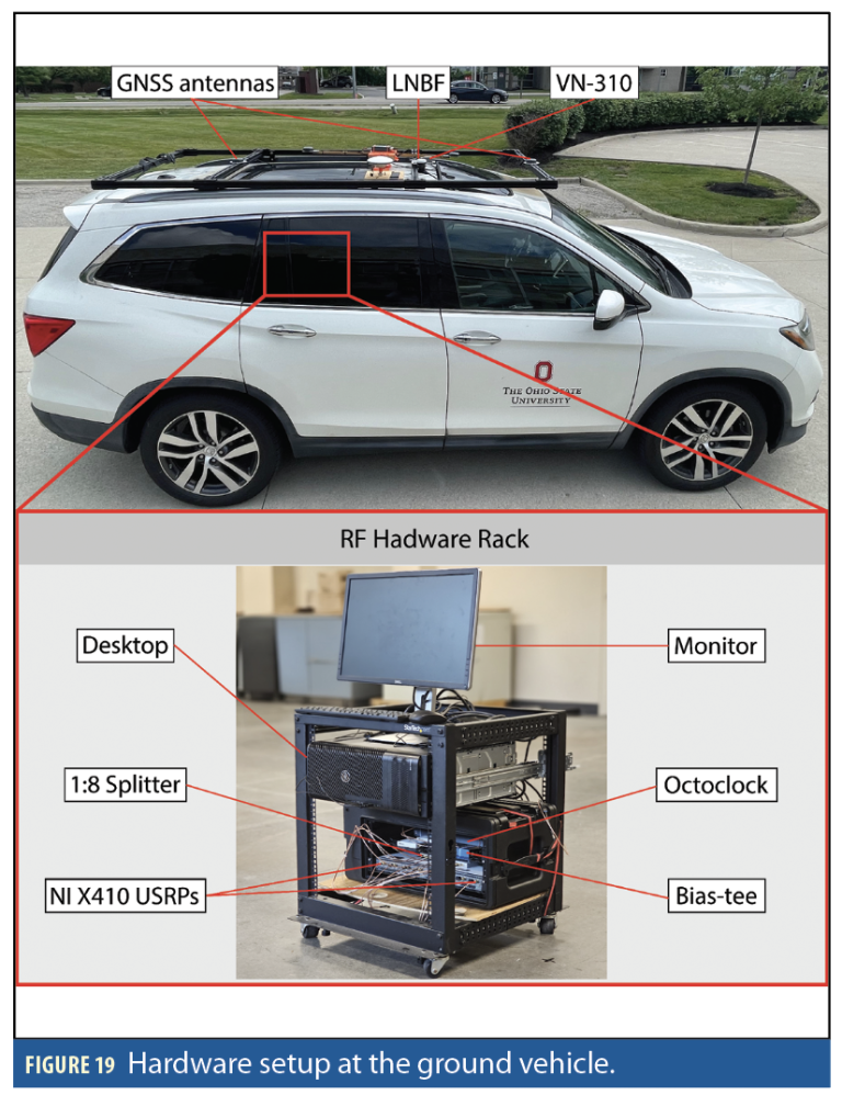
- Ground vehicles(Pennsylvania): A vehicle equipped with an inertial measurement unit (IMU) and barometric altimeter continues navigation using Starlink signals after GPS signal loss.
- Drone(Ohio): First demonstration of a drone navigating solely using Starlink signals, incorporating tight coupling of Doppler measurements with IMU
- stratospheric balloon(New Mexico): Validating signal reception capability at extreme altitudes
- Arctic waters vesselsNear Greenland: Testing Maritime Navigation in High-Latitude Polar Environments
The combined multi-constellation positioning experiment was even more impressive: using signals from 4 Starlink, 2 OneWeb, 1 Orbcomm, and 1 Iridium satellites simultaneously, it achieved a 5.1-meter 2D positioning error, starting from an initial estimated position 3,600 km off.
Required hardware: under $200
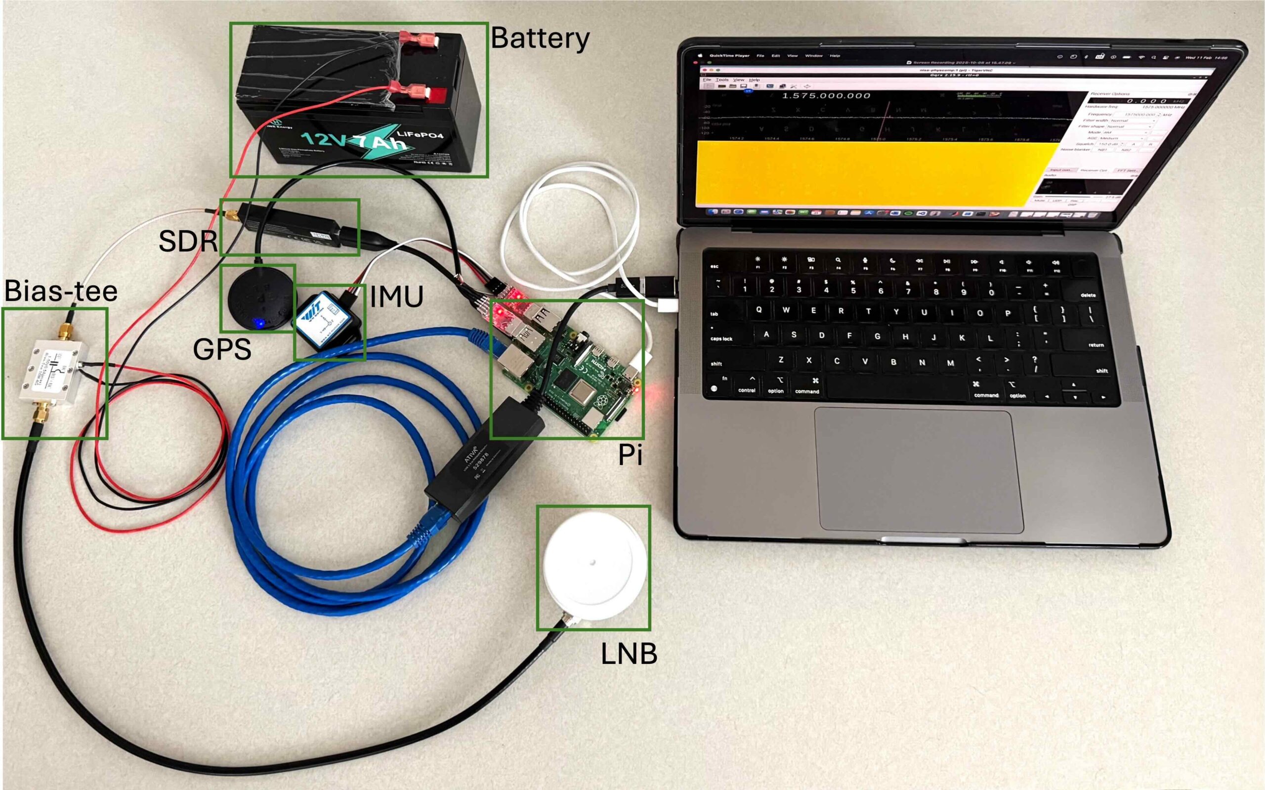
This passive positioning system has surprisingly low hardware requirements:
- RTL-SDR Blog v4USB software-defined radio receiver, about $35 (approximately NT$1,140)
- Ku band LNBA low-noise block downconverter for satellite TV, about $20 USD (approximately NT$650)
- Ku band parabolic antennaA small satellite antenna, about $50 (approximately NT$1,625)
- Raspberry Pi 5: 8GB RAM version for running signal processing algorithms
- Bias T adapterPowering the LNB
- USB power bank: 5000mAh power supply
The core algorithm uses Python along with open-source libraries such as pyrtlsdr, skyfield, and numpy, utilizing publicly available TLE (Two-Line Element) data from Celestrak to distinguish between different satellites, and then calculates geographic coordinates through the Doppler frequency shift of at least three satellites.
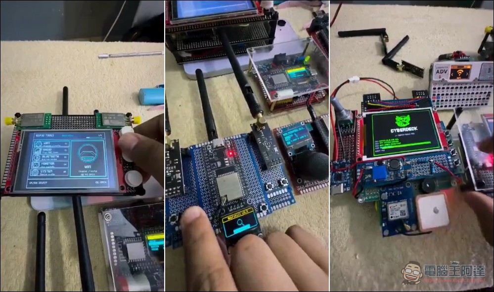
Recently, a story has been circulating online about a 16-year-old boy who built a Starlink receiver. After our extensive verification, we believe this is just an internet rumor designed to generate clicks. The device shown in the video is likely not a GPS positioning system, but rather something more similar to a WiFi signal receiving or cracking setup. On the screen, you can also see content that looks more like a hardcore hacker’s wireless network cracking equipment rather than a GPS receiver. Furthermore, all the videos simply copy the same content without any relevant explanation or source attribution.
一名16岁少年自主研发出简易星链信号定位装置,靠这款产品赚到30万美元。
该设备可捕捉卫星广播信号,不受地理区域限制,在任何地方都能实现定位。
就算SpaceX想限制相关信号接收,少年也提前做好了完整的合规准备。
整套设备的研发思路并不复杂,全程借助Claude完成代码开发:… pic.twitter.com/5IMEWwYFCN
— 景珩 (@JH_5200) July 4, 2026
Military closely monitoring GPS contingencies
The funding sources for this research reveal military interest: the Office of Naval Research (ONR), Air Force Office of Scientific Research (AFOSR), and the U.S. Department of Transportation (DOT) all provided funding. The underlying reason is the growing exposure of GPS vulnerabilities. A column in Inside GNSS notes that GPS jamming and spoofing attacks have occurred in multiple locations worldwide, from the Mediterranean to the Middle East, Black Sea, South China Sea, Baltic Sea, and Atlantic Ocean, stating that “GPS jamming and spoofing have become routine in electronic warfare.”
In February 2026, the Rochester Institute of Technology also publishedPaperDemonstrates a 9D navigation system (3D position, 3D velocity, 3D attitude) fusing Starlink beacons with GPS and inertial measurement units, further validating the feasibility of Starlink as a GPS backup.
Passive positioning system by the Polish team
This technology is not exclusive to the United States. A team led by Professor Pedro Gómez-del-Hoyo at Warsaw University of Technology has also developed a passive self-positioning system based on Starlink signals, using a frequency-based positioning scheme. They presented simulation and real-signal test results at the 2025 IEEE conference, confirming the feasibility of the approach.
This technology still has clear limitations:
- Reference station requiredThe most precise positioning solution requires a reference receiver at a known position to correct satellite ephemeris errors. While the distance between the reference station and navigation user can span hundreds of kilometers, infrastructure still needs to be built.
- Starlink Undisclosed Signal SpecificationsSpaceX has never publicly disclosed the detailed structure of its downlink signals, so researchers must use reverse engineering and cognitive SDR to learn the signals in real time.
- Ephemeris and timing errorsThe accuracy of publicly available satellite orbital data is insufficient, and Starlink’s timing synchronization errors are not disclosed.
- Non-cooperation riskSpaceX may change the signal structure or beacon transmission strategy at any time
The gap between academic research and commercial products
Back to the opening question: Can hardware costing under $200 replace GPS? Academic research answers that it is “completely feasible in principle, with accuracy that can even rival GPS.” A positioning accuracy of 2 meters is already on par with the 0.3 to 5 meters accuracy of standard GPS receivers.
However, there is still a considerable gap between a laboratory prototype and a stable, usable product. The complexity of signal processing algorithms, the need for reference stations, and the risk that Starlink signal specifications could change at any time all mean that this technology is currently positioned as a supplementary backup to GPS, rather than a direct replacement in the near term.
For ordinary consumers, this might still seem like nothing more than an interesting research breakthrough. But for military, maritime, aviation, and remote area applications, a GPS-independent backup positioning solution is moving from papers to reality.
Source: KOCPC Chinese