


Nowadays, the degree of development of the combination of AI and drones may have exceeded your imagination. A developer on X used Meta’s open source Segment Anything Model 3 (SAM 3) AI model, which combined high-resolution aerial photography and LiDAR laser point cloud scanning to fly a drone over an entire cemetery and brought back a complete 3D terrain model, as well as the precise location and outline of 9,940 tombstones. No one manually drew the whole process, and the AI model automatically completed the complete process of image recognition and CAD drawing output. Tasks that used to take measurement teams weeks to complete are compressed into a fraction of the time.
A drone just mapped an entire cemetery and found 9,940 individual grave headstones on its own in 21 minutes
A 335 megapixel scan gets fused with 134 million lidar points, building a full 3D model of the terrain down to 5cm resolution
An AI model called SAM3 scans the imagery… pic.twitter.com/ZGCVDmVjat
— pulmencr (@pulmencr) July 24, 2026
Technical teardown: from aerial scans to CAD drawings
The first layer of this workflow is sensing data acquisition. The camera on the drone captures 335-megapixel ultra-high-resolution aerial images, while the LiDAR sensor emits laser pulses and collects 134 million three-dimensional point cloud data points. After merging the data from the two sensors, the system creates a complete 3D terrain model with a resolution of 5 centimeters, and the height, shape and relative position of each tombstone are accurately recorded.
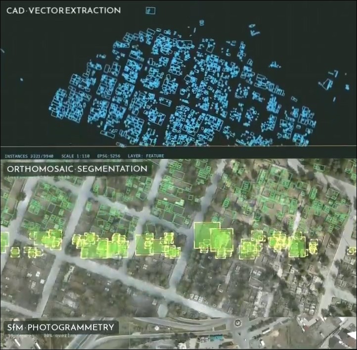
The second layer is AI automatic identification. Tasked with this task is Meta’s Segment Anything Model 3, or SAM 3, released in March 2026. The biggest feature of this model is that it supports “concept segmentation”. Users only need to enter a text prompt (such as “headstone”), and the model will automatically scan the entire image, identify and outline the outline of each object that matches the concept. There is no need to pre-train customized models or manually label training data, and it can operate directly with zero samples.
The third layer is vector output. Each tombstone outline recognized by SAM 3 is automatically converted into CAD vector format, which can be directly exported as engineering drawings for subsequent surveying, planning or cadastral management.
SAM 3: Meta’s universal image segmentation model
SAM 3 is Meta’s latest basic model in the field of computer vision, built on the basis of the previous two generations of SAM and SAM 2. Compared with the previous generation which could only segment a single object based on clicks or box selections, SAM 3 introduces the ability of text prompts and example prompts, which can detect, segment and track all objects belonging to the same concept in an image or video at once.
This capability is particularly valuable in the geospatial domain.Wherobots The company has integrated SAM 3 into its RasterFlow earth observation inference engine and tested it on 133 GB of aerial photography data from the U.S. National Agricultural Imagery Project (NAIP). It successfully automatically detected targets such as building roofs, roads, containers, and agricultural machinery with text prompts, and directly output them as vector geometric data.
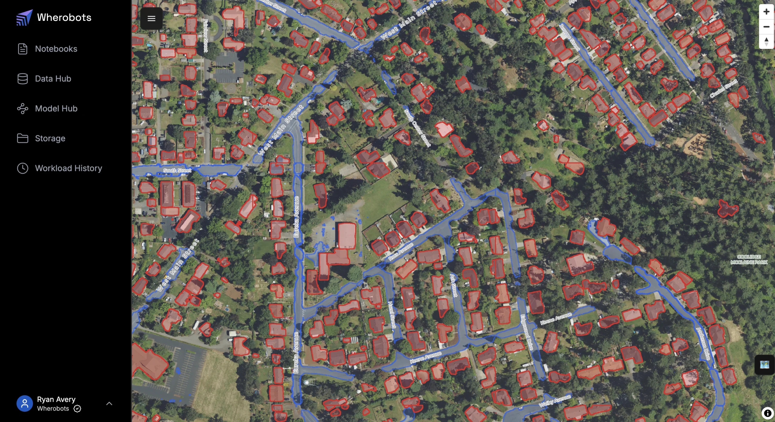
The source code of SAM 3 is released as open source on GitHub and has accumulated a large number of citations and community contributions as of this writing. For the surveying and geographical information industry, image interpretation work that required a lot of manpower in the past can now be automatically completed through an open source model and appropriate prompt words.
Cemetery digitization: an emerging application scenario
Cemetery surveying and management require significant human input. Surveyors must personally visit each tombstone, manually record the location, measure the dimensions, and then compile the results into drawings. In a large cemetery with tens of thousands of headstones, this work can take weeks or even months.
GeoCue CorporationThe TrueView 515 LiDAR system has previously been used to scan the historic Westview Cemetery in the United States and successfully discovered many hidden graves covered by vegetation, providing key topographic data for the restoration and preservation plan.
In early 2026, The Conversation in the United States reported on a university course project in which environmental scientists led more than 50 students to use drones, mobile phones and GIS technology to build a digital map of a historical cemetery with 6,000 tombstones but almost no records. The above cases all show that cemetery management is moving from paper registration to digitalization, and the combination of AI and drones has greatly accelerated this process.
The method of this demonstration pushes the entire process to the extreme: from takeoff to output of CAD drawings, it is completed in a short time. The traditional method requires surveyors to spend weeks manually mapping thousands of objects, which are processed by AI in the image scanning stage. For agencies that manage large cemeteries, need to regularly update cadastral information, or perform spatial planning, this efficiency gap is enough to change the entire workflow.
Technical limitations and scope of application
This pipeline is not without prerequisites. First of all, high-quality 335-megapixel aerial photography and LiDAR scanning require professional-grade drone equipment, and the hardware cost is much higher than that of general consumer drones. Secondly, the recognition effect of SAM 3 depends on the image resolution and the visibility of the tombstones. Tombstones that are completely covered by dense vegetation or severely weathered and worn may not be accurately detected.
In addition, although CAD vector output eliminates the step of manual drawing, the output results still need to be verified and corrected by professional surveyors, especially in cadastral survey scenarios that require legal validity. The accuracy of AI recognition will be affected by factors such as light, shadow, tombstone spacing, etc., and it is impossible to achieve 100% accuracy.
However, even taking into account the above limitations, this pipeline still represents an order of magnitude improvement in efficiency compared to traditional approaches. Even if 5% to 10% of the identification results need to be manually corrected later, the overall time required is still much lower than that of a full manual operation.
From cemetery to city: A bigger imagination for AI vision
Cemetery scanning is just one specific use case for SAM 3 in the geospatial domain. Wherobots’ testing has proven that the same set of technologies can be extended to a wider range of scenarios such as building detection, road identification, agricultural land classification, disaster damage assessment, etc. When AI can directly extract structured vector data from satellite or aerial images with text prompts, the “image interpretation” link that takes the longest time in the traditional GIS workflow is greatly compressed.
The speed at which this demonstration video spread on the Internet also reflects the industry’s high level of concern for the “AI + drone” combination. When a job that used to take a professional team several weeks can be completed in a short time, what is affected is the entire business model of spatial data acquisition and processing.
Source: KOCPC Chinese