


arriveJapanWhen traveling on your own in Kyoto, the most troublesome thing is not that there are too many attractions, buttransportationHow to match. especiallyKyotoThe urban area is dominated by buses, and the routes are complicated and divided into multiple operators. I often give up first just by looking at the official map. However, in fact, as long as you install a practical traffic inquiry app on your mobile phone, you can greatly reduce the risk of getting lost and taking the wrong bus.
This article is going to share a free app specially designed for Kyoto, supports Chinese interface, and can query multiple bus systems at the same time. App, whether you are looking for routes, checking timetables, or even locating bus stop signs, you can do it all at once. As long as you know how to use this tool, even if it’s your first time in Kyoto, you can safely run your trip to the fullest.

No more traffic jams for free travel in Kyoto Kyoto Transit Planner bus inquiry app must-install guide
Planning KyototravelWhen traveling, most people feel confident at first. Information about attractions is easy to find, and the list of coffee shops and shrines fills a whole page. But when it comes to arranging the lines, I realize that the problem is not where to go, but how to get there. The main form of transportation in the Kyoto urban area is buses, with dense routes and numerous operators. They are completely different from the common rail systems in Taiwan or Tokyo.
For out-of-town travelers, the dispersion of transportation information is a barrier in itself. In addition, official websites are mostly in Japanese, and they have to understand the route number, driving direction, and stop sign location at the same time. It is easy to be discouraged before traveling.

In fact, transportation in Kyoto is not difficult to solve, it just requires a “right tool”. If you continue to use a general Japanese transportation app, you will often be overwhelmed by too much unnecessary information; but if you switch to a query tool specifically designed for Kyoto, the situation is completely different.
The Kyoto Transit Planner App introduced today is born for this need. It is the official app version launched by the Kyoto transportation inquiry website “Walking Kyoto Transfer Plan”. It has a very clear positioning and focuses on handling the bus and subway mobility needs in the Kyoto urban area. The target group is independent travelers.
Moreover, Kyoto Transit Planner App supports both iOS and Android platforms, so travelers who are iPhone or Android users can use it.
Compared with transportation apps covering all of Japan, the biggest feature of Kyoto Transit Planner is its “trade-offs”. It does not attempt to cover all transportation scenarios, but rather focuses on the bus systems that are most commonly used by tourists and are most prone to errors.
The app integrates multiple systems such as Kyoto City Bus, Kyoto Bus, Keihan Bus, Keihan Kyoto Transportation Bus, and West Japan JR Bus, allowing users to plan directly from the starting point to the destination without having to identify the bus operator first. Coupled with the support for Chinese interface, the learning cost for non-Japanese users is significantly reduced.
Start with “Where do I want to go?” rather than studying a road map
If you have ever tried to understand a Kyoto city bus map, you should be deeply impressed by the dense lines on it. Kyoto Transit Planner deliberately avoids this design and instead uses start and end point search as its core operation method.
After opening the app, the default screen is the route search page. The lower part is mainly divided into two functions: route search and timetable station map. As long as you enter the name of the departure place and destination, the system will automatically list possible ride options. Users do not need to judge which line or number to take. This design is especially suitable for travelers who don’t want to spend time studying transportation details.
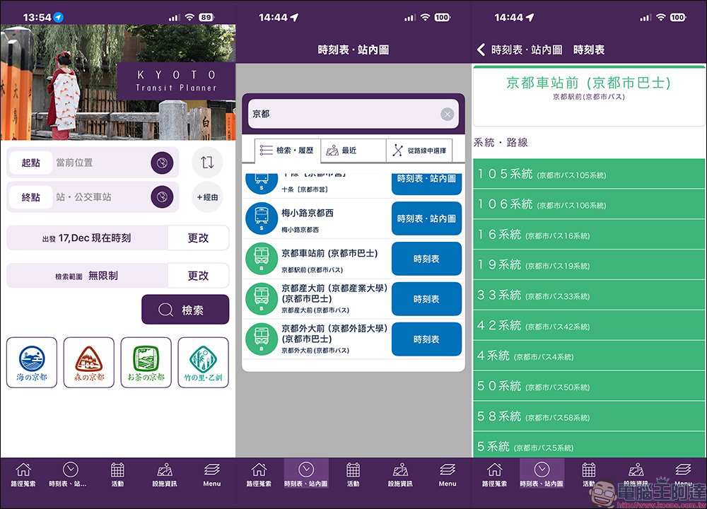
Input details that need to be paid attention to when making actual inquiries
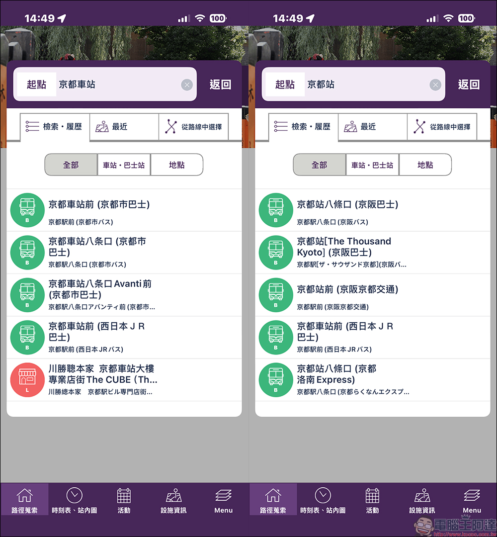
In actual operation, there is a small detail that deserves special attention. Since the original data of the system comes from the Japanese database, some place names will have differences between Traditional Chinese and Japanese Kanji.
For example, when searching for Kyoto Station, entering “Kyoto Station” may not display the complete bus system, such as Keihan Bus, Keihan Kyoto Transportation Bus, etc. However, as long as you switch to “Kyoto Station”, the routes of Kyoto City Bus, Kyoto Bus and other operators will appear together. This is not an app fault, but a limitation in translation and data correspondence. It will be much easier to understand this before use.
Understand the route at once, map mode is the key
After completing the search, Kyoto Transit Planner will list multiple candidate routes and display them in map mode by default. This screen is not for you to confirm details, but to quickly compare the overall status of different options, such as travel time, whether transfers are needed, and the general direction of movement.
If you need to further confirm the actual bus location, just zoom in on the map and you will be able to see the corresponding waiting area, such as which stop in front of Kyoto Station to get on the bus.
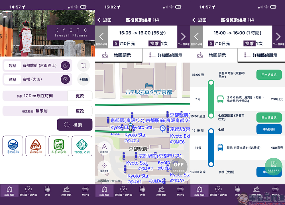
Then switch to the detailed route display to clearly understand the bus number and driving direction. Although most of the bus stop information on the detailed route page only provides timetables, viewing it with a map is still enough to prepare for the actual ride.
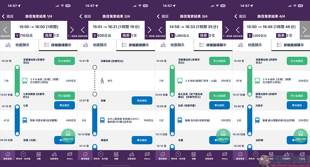
In some cases, the app will also suggest ways to take the subway and bus together. This type of route may seem like there are more steps, but the actual ride time may be shorter, and you can avoid being crowded on the bus for a long time. This alternative is easily overlooked without tool assistance, but through Kyoto Transit Planner’s integrated display, it can be quickly included in the comparison.
The difference in query efficiency for short-distance movement in urban areas is obvious
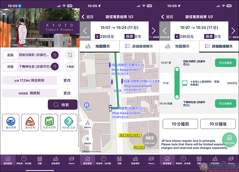
Take the common route from Shijo Kawaramachi to Shimogamo Shrine in the urban area as an example. As long as you enter the correct place name form, the system can usually quickly list a route that is short and requires no transfers. By viewing the map, you can also confirm whether the stop sign is located in a conspicuous location, such as a department store or in front of a major intersection.
After entering the detailed route page, the bus number and driving direction are clear at a glance. For passengers who take a bus in Kyoto for the first time, the psychological pressure will be significantly reduced.
Timetable function is suitable for people who need to accurately control their itinerary
In addition to route planning, Kyoto Transit Planner’s timetable function is also quite useful. After switching to the timetable station map from the bottom of the homepage, set the station name to view the departure time of each route.
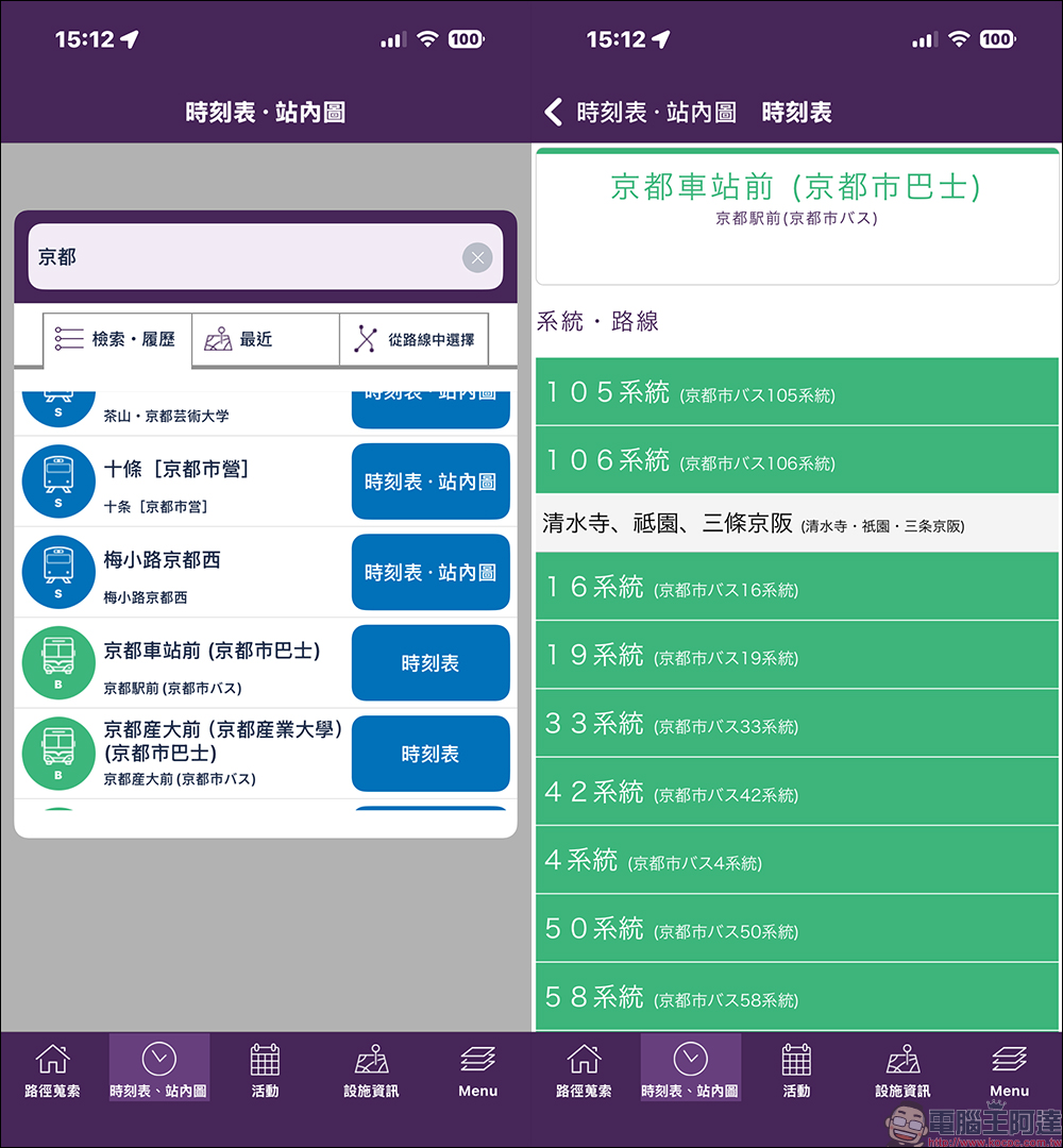
Taking Kyoto City buses as an example, the circulation system will clearly distinguish the left and right loop directions to avoid taking long detours in the wrong direction. After entering a single route, you can also check the waiting area number and departure time of the day, and switch to other dates for inquiry, which is especially helpful for passengers who need to accurately control their time.
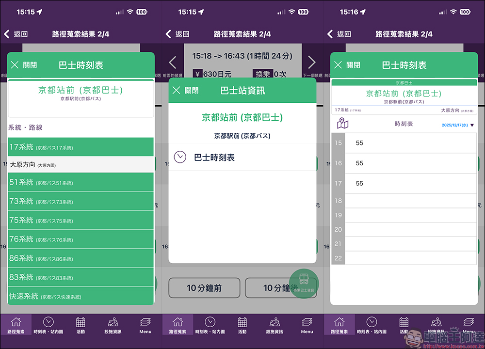
In addition, for Kyoto bus sections, such as the No. 17 and Tetsu No. 17 routes to Ohara, complete times can also be found in the app. However, the relevant information is relatively simple to present, and the location of the stop sign usually needs to be zoomed in with a map to confirm.
The frequency of these two routes is about one hour, and the times are staggered. They can be used interchangeably when actually planning the itinerary to increase flexibility.
Conclusion
Overall, Kyoto Transit Planner is not the most gorgeous transportation app, but it knows exactly what problem it is trying to solve. By integrating multiple bus systems in Kyoto city and providing intuitive route search and map display, it has successfully reduced the cost of understanding Kyoto traffic for independent travelers.
Although the Chinese interface still has some input limitations, as long as you master the basic operation logic, this app can cover most bus movement scenarios in Kyoto city. For travelers who are visiting Kyoto for the first time, or who plan to rely heavily on buses for transportation, it is indeed a practical tool worth adding to the pre-trip preparation list.
Kyoto Transit Planner App Download:
iOS(App Store)|Android (Google Play Store)
Further reading:
Source: KOCPC Chinese