


When trying to get from A to B, almost everyone pulls out their phone and opens Google Maps. Whether it’s your go-to everyday mapping app or you only use it when traveling, millions of people around the world rely on Google Maps to find their way around, but is that its only use? No! This is just the shallowest feature of Google’s signature GPS. In addition to generating route navigation, there are many ways to use Google Maps that you haven’t discovered yet.
Tips for using Google Maps you may not know
Even the main route navigation function of Google Maps can greatly enhance your travel experience. You can use it as a tool to discover various local services, landmarks, events and other information. It is also a good transportation planner, no matter which mode of transportation you use, you can get help from it, making daily commuting, travel, etc. easier. If you don’t know where else it can be used, the examples given below are very common, but they are not the only ones.
Share real-time location
If you’re traveling to meet someone in a strange place, or maybe you’re at a theme park with your family, scattered among the crowd, either way, sharing your current location is a more convenient way to find each other than text messages or phone calls. Another practical function of real-time location sharing is that when you are exploring new places alone with your luggage, if the GPS and network signals are good, your loved ones can keep an eye on your whereabouts, giving them more peace of mind.
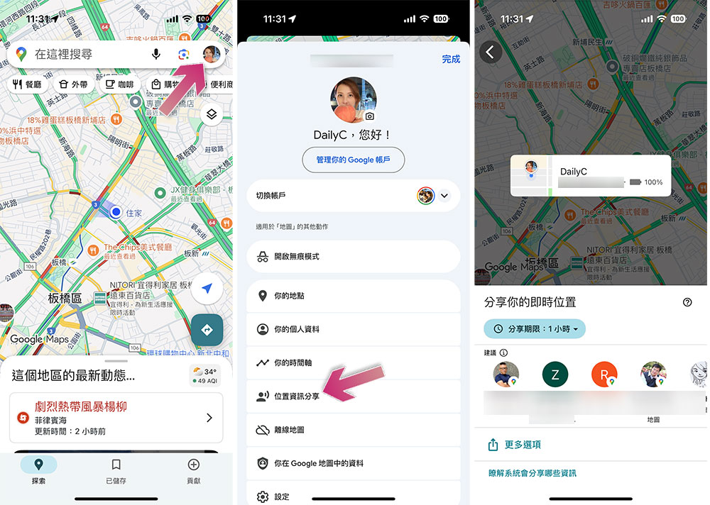
To share your real-time location on Google Maps, follow these steps:
- Click on your profile picture in the upper right corner.
- Select “Location Sharing”.
- On this page you can choose who to share your real-time location with, the time for sharing, etc.
Find electric vehicle charging stations
Electric vehicles are becoming more and more popular, and at the same time, the number of charging stations has begun to increase, but their number is far less than that of gas stations. In fact, charging infrastructure is a problem that electric vehicles need to solve. When you need to charge your electric car, you’ll need to do a little more searching than a traditional car owner, but don’t worry, Google Maps can help you find it faster.
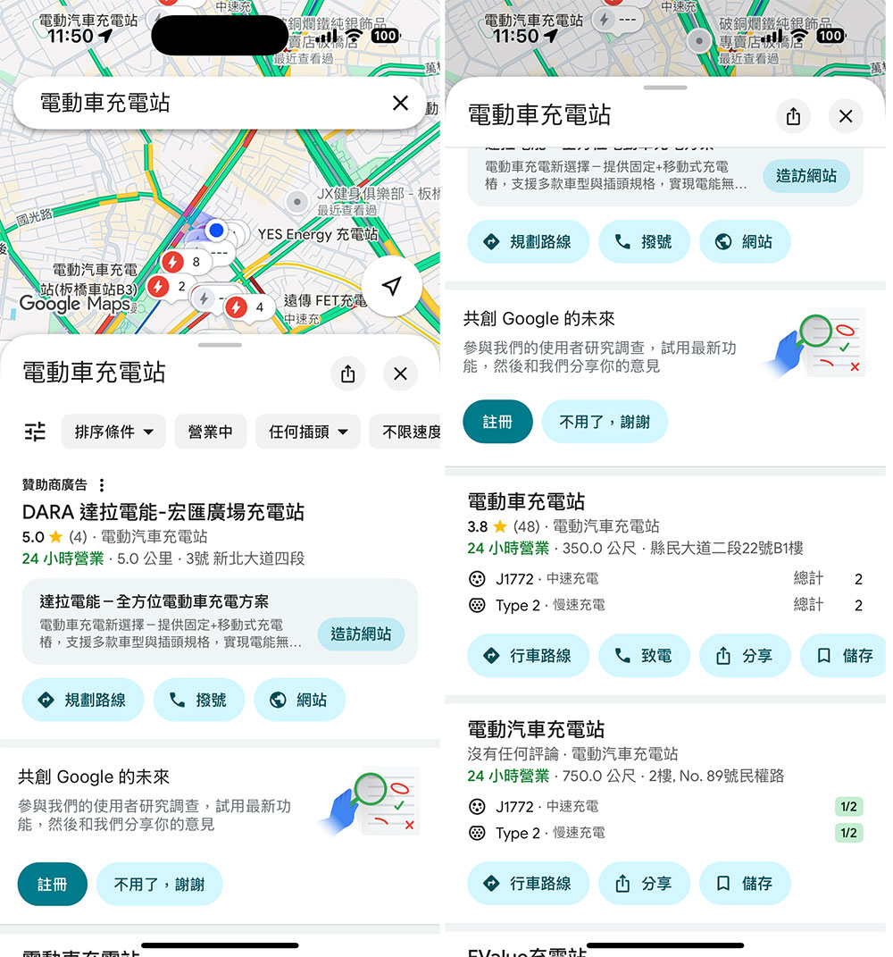
If you want to quickly find the location of an electric charging pile, you can follow the steps below:
- Open Google Maps.
- Enter “electric vehicle charging station” in the search field
- In addition to seeing how to get there, you can also see the available charging street modes in the location details, as well as reviews, phone numbers, business hours and other related information when you usually check the location.
Remember where you parked
Whether you’re heading to an amusement park or exploring a new city, parking your car and setting off on foot means you’ll eventually have to return to where you started to pick up your car. Parking can be difficult to find, especially if there aren’t any clear landmarks to help you remember where to park. Google Maps has a dedicated feature that helps you retrace your steps without testing your own memory.
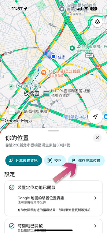
To use this feature, do this:
- Once you’ve parked your car, stand next to your car and open Google Maps.
- Click the little blue dot at your current location.
- Select “Save Parking Location”.
- When you want to pick up your car, just enter “parking location” in the search bar to navigate the route back to your car.
Measure the distance between points
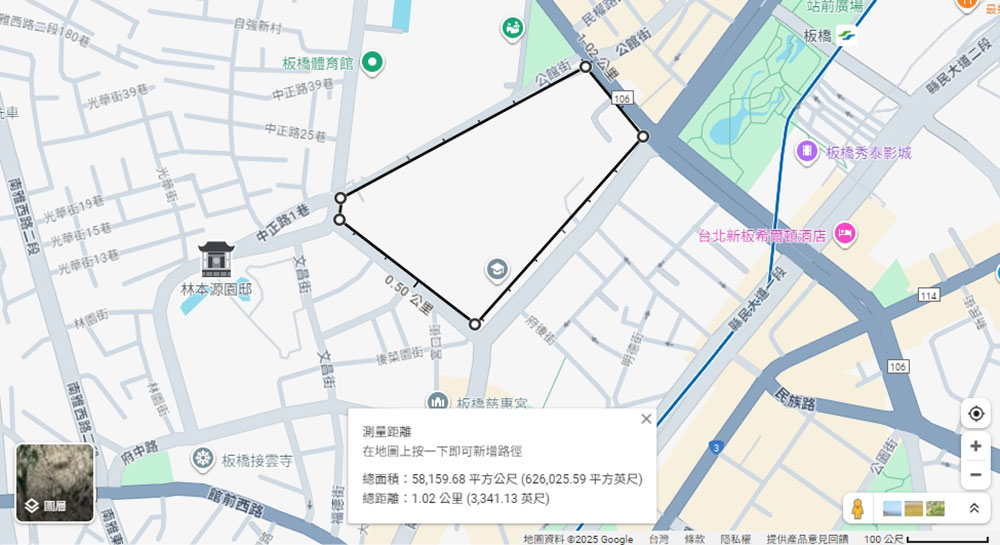
When using Google Maps to navigate, it plots a route based on how you would drive or walk to that location, in other words, it won’t always take the shortest route between points. But Google Maps also lets you measure aerial distance between locations, which can be helpful if you want to know how far away two points are, especially when calculating fitness routes or measuring large tracts of land. The only real limitation of this system is the low accuracy of many locations on Google Maps.
To measure distance on Google Maps, do this:
- Open Google Maps for the web on your browser and find your starting point.
- Right-click on your starting point and select “Measure Distance” from the drop-down menu that appears.
- Then click on another location to see the distance, area, etc. To add multiple points, please click on each point in sequence. If you make a mistake or need to delete a point, just click again and it will disappear.
Check traffic at stores, restaurants and parks
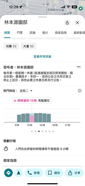
If you’re like me and don’t like going to stores or restaurants during rush hours, you may have used this trick. Google Maps provides real-time information about a place’s popularity, so you can decide whether to go now before you visit. Usually when you search for a place, Google Maps will automatically tell you if your destination area is at peak traffic times, but you can also check some statistics on how busy a particular place is on what days and times.
To check the crowd status you can do this (this feature is available for specific businesses and locations, as well as some public areas):
- Open Google Maps.
- Find the business or location you’re looking for.
- Scroll down the details section and you can see the crowd status for each time period in that block. If an area is busier than usual, Google will apply a special label.
Explore the city from a distance
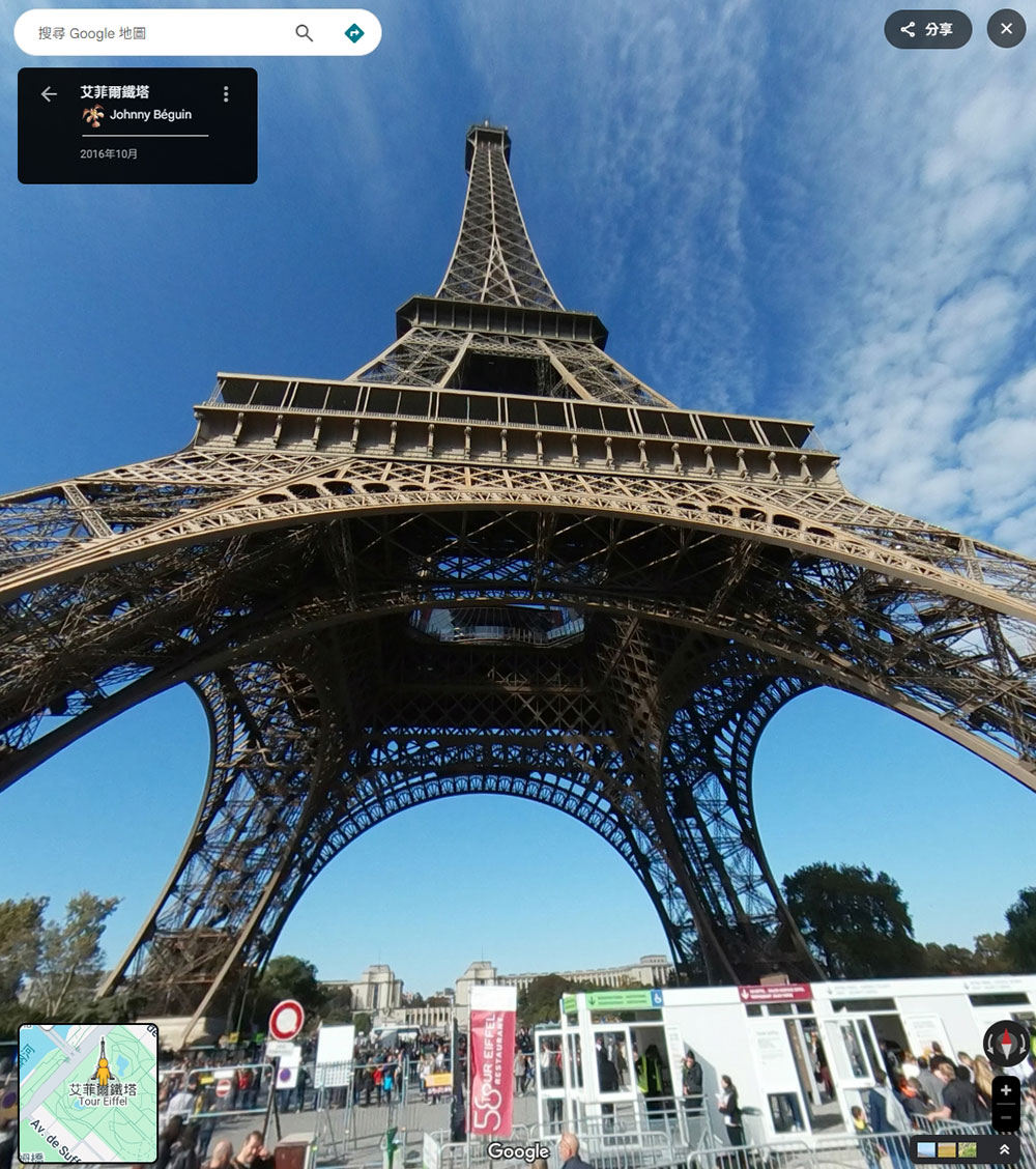
If you don’t have the budget to travel around the world, Google Maps offers a great alternative that isn’t exactly the same thing, but can be fun. By using the Street View function, you can roam the world’s largest and most popular cities as if you were walking on the streets in person, without the need for a passport or air ticket. Street View is available on mobile devices and computers.
- Open Google Maps and enter your desired destination, such as Miami, Paris, etc.
- Zoom in on the area you’re interested in viewing in more detail.
- For the computer version, please click on the orange man in the lower left corner of the screen. If you are using a mobile device, you can click on the layer icon and select Street View.
- Then click on the area you want to explore and view the area as if you were walking.
- You can also “move around” using the arrows at the bottom of the image, or drag the cursor around the screen or turn with your finger for a 360-degree view.
Check air quality
Air quality is not a factor that many people consider when traveling, but if you have allergies like the author, then knowing the outdoor air quality before going out can make preparations in advance or decide whether to travel to this location.
To view the real-time air quality index on Google Maps, do this:
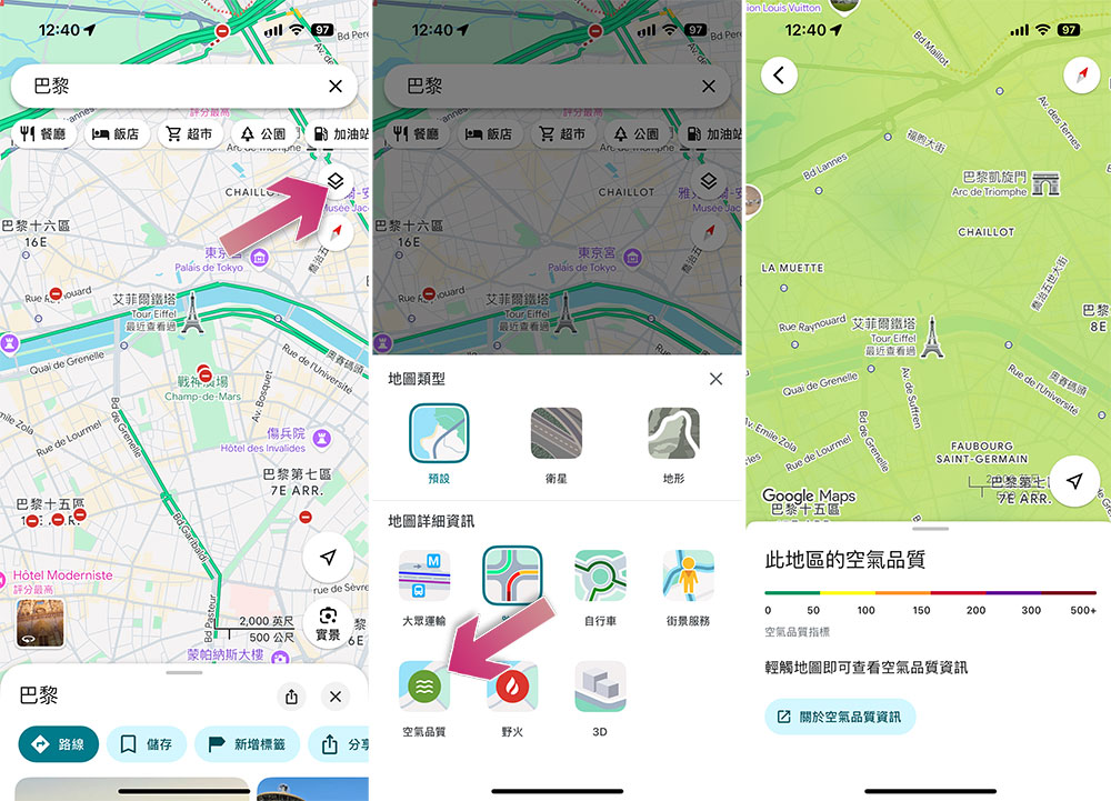
- Open the Google Maps app and find the location you want to confirm.
- Click the layer icon next to it and select “Air Quality” from it.
- If the location you selected is shown in green, it means the air quality index is below 50 points. The highest AQI score is 500, with lower numbers indicating less pollution and vice versa. 0-50 is good air quality, 51-100 is moderate, 101-299 may be unhealthy for some, and anything above 300 is considered unsafe.
Source: KOCPC Chinese